The following is from the National Weather Service and Carroll County EMA:
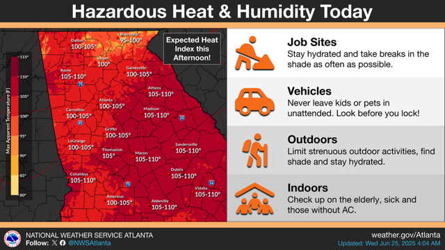
A Heat Advisory remains in effect through 8 PM this evening for all of East Alabama and West Georgia, with dangerously high temperatures and humidity expected to create hazardous conditions. Daytime highs will range between 95 and 100 degrees, and when combined with high humidity, heat index values could climb to between 105 and 109 degrees. These conditions pose a significant risk of heat-related illnesses, especially for individuals engaging in outdoor activities, vulnerable populations such as the elderly, young children, and those with chronic health conditions, as well as pets. Residents are advised to take extra precautions by staying hydrated, avoiding strenuous outdoor activity during the hottest part of the day, and checking on those who may be more sensitive to heat. It is also important to ensure pets have access to shade and plenty of water.
In addition to the heat, scattered thunderstorms are expected to develop across the region this afternoon and continue into the evening and overnight hours. The atmosphere is primed with heat and moisture, which will contribute to the potential for some storms to become severe. The Storm Prediction Center has placed most of the area under a Slight Risk, or level 2 of 5, for severe weather today and tonight. The main threats with these storms will be damaging wind gusts of 50 to 70 miles per hour and hail up to the size of quarters. Frequent lightning and locally heavy rainfall are also possible, which could pose hazards for outdoor events and activities. Storms may organize into clusters, increasing the threat and coverage of damaging winds.
Timing for the severe weather threat varies slightly across the region. In Alabama, isolated to scattered thunderstorms are expected to develop between 2 PM and 10 PM, while in Georgia, storm activity is more likely after 4 PM. The most organized and potentially severe storms are expected between 6 PM and 4 AM Thursday in Georgia. Residents are urged to monitor forecasts and have a plan in place, especially if involved in any outdoor or weather-sensitive activities.
Looking ahead to Thursday, unsettled weather will continue with additional thunderstorms expected during the afternoon and evening hours. A Marginal Risk, or level 1 of 5, for severe weather is in place areawide. While the threat is lower than today, a few storms could still become strong enough to produce damaging wind gusts. The most likely time for storms on Thursday will be from 2 PM to 10 PM.
Forecast confidence is high regarding the dangerously hot conditions today and the general development of thunderstorms later this afternoon and evening. However, confidence is lower when it comes to the precise timing and movement of individual storms in any one location.
In summary, residents across East Alabama and West Georgia should prepare for extreme heat and the possibility of severe thunderstorms today, followed by a continued chance of strong storms on Thursday. Stay informed by checking local forecasts regularly, take heat precautions seriously, and be ready to respond to changing weather conditions.