
For Closing and Cancellations please visit our media friends at Newstalk1330 by clicking here.
As of January 16, 2022 at 8:30am
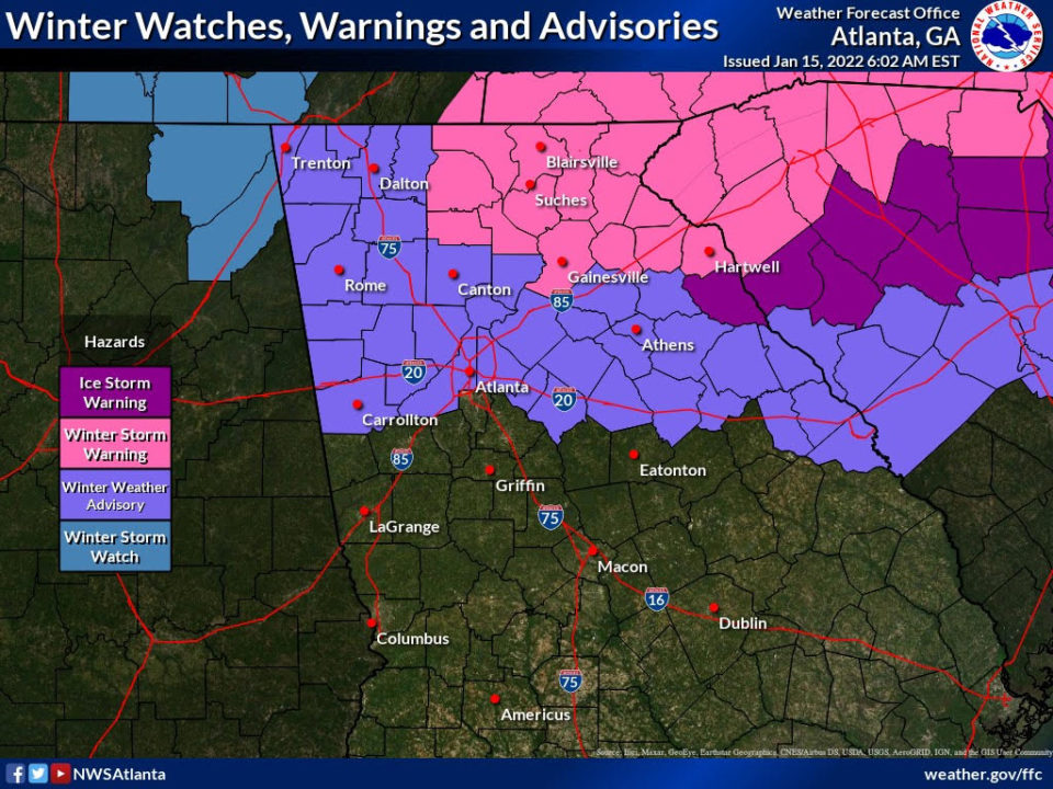
NWS Atlanta has issued a Winter Weather Advisory for additional counties in our coverage area: Heard, Troup, and Coweta. Additionally, NWS Birmingham has issued a Winter Weather Advisory for our eastern Alabama coverage area: Cleburne, Randolph, and Calhoun. Snow has begun to fall in Opelika, AL, Valley, AL and snow in Newnan. Sleet in Carrollton.
As of January 15, 2022 at 5:20pm
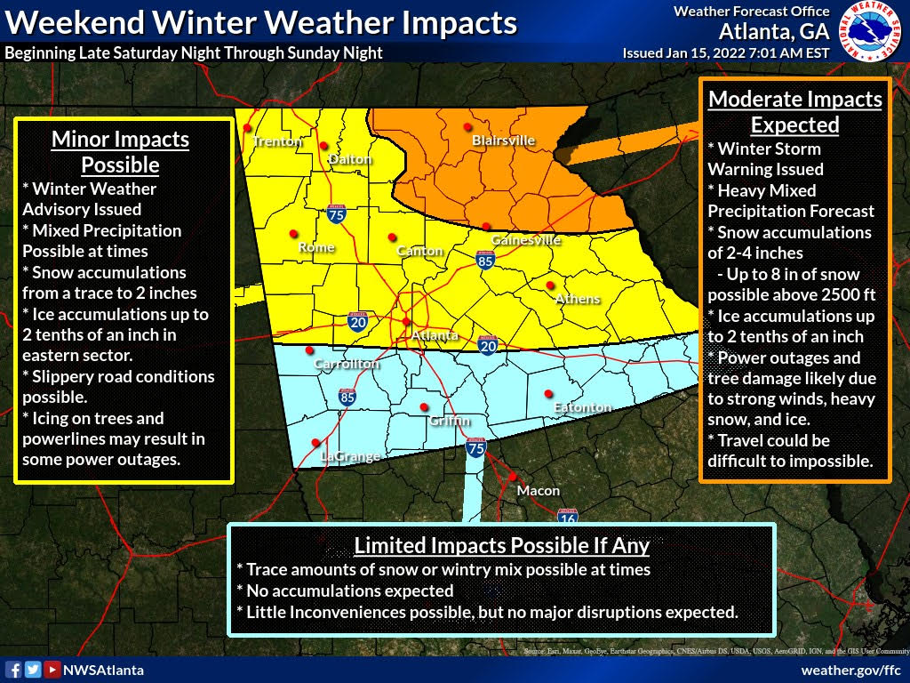
NWS Atlanta has upgraded the Wind Advisory to a High Wind Warning for most of our coverage area in Georgia. Additionally, impacts of the storm, primarily on the wind side, are now expected to reach further south than anticipated. Please see the above graphic for more information.
As of January 15, 2022 at 3:00pm
The NWS in Peachtree City held a special weather briefing this afternoon regarding this weekend’s potential winter weather that could begin as early as overnight Saturday into Sunday. Here are the highlights:
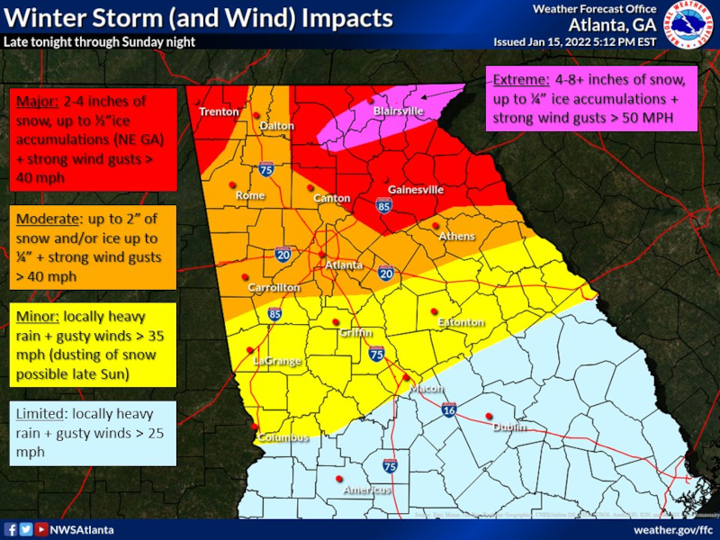
A Major Winter Storm will impact parts of North Georgia beginning tonight through Sunday evening.
- East Alabama is under a Winter Weather Advisory from 6:00pm Saturday through 9:00pm Sunday and also under a Wind Advisory from 6:00pm Saturday until 6:00am on Sunday.
- Carroll County, Douglas County, and points northward are under a Winter Weather Advisory from Midnight Saturday/Sunday through Midnight Sunday/Monday and under a Wind Advisory from midnight Saturday/Sunday until Midnight Sunday/Monday.
- Coweta County, Heard County, and points southward are NOT included in the Winter Weather Advisory at this time. However, those areas could see a trace to 1 inch of snow and ARE included in the Wind Advisory.
- Freezing Rain (Ice) and/or Snow will occur north of I-20 and is possible for areas south of I-20.
- Snow accumulations in our area are forecast to be a trace up to 2 inches of snow and up to 1/10 inch of ice. Locally higher amounts are possible within our area. Winter precipitation in our area is forecast to begin between 3:00am and 7:00am Sunday morning, continuing throughout the day.
- Strong winds are a concern for Sunday. Sustained winds between 20-30 mph with wind gusts as high as 50 mph are possible for our area on Sunday.
- The combination of snow, ice and wind gusts greater than 35 mph could cause significant power outages with this system.
- NWS Atlanta has shared their 21-minute Special Weather Briefing on their YouTube channel which you can watch here.
Please make preparations now as these type systems are highly unpredictable in Georgia but the NWS is encouraging everyone to make plans now as they have not seen a system like this in Georgia in the last few years.
As of January 15, 2022 at 8:00am
From Tim Padgett with Carroll County EMA:
The National Weather Service (NWS) has issued a Winter Weather Advisory and a Wind Advisory for Carroll County and points northward. Please see the specific information below:
- A Winter Weather Advisory has been issued from midnight tonight through midnight Sunday night.
- Rain mixing with or changing to snow, sleet and freezing rain. Total snow accumulation from 1 – 2 inches. Total ice accumulation from 1/10 to 2/10 of an inch.
- Onset of winter precipitation after midnight tonight, continuing all day Sunday and tapering off by midnight Sunday night.
- Higher snow and ice accumulations will occur further east of our area.
- Make plans for slippery road conditions
- Rain mixing with or changing to snow, sleet and freezing rain. Total snow accumulation from 1 – 2 inches. Total ice accumulation from 1/10 to 2/10 of an inch.
- A Wind Advisory has been issued for East Alabama from 1800 hours tonight through 1800 hours Sunday. A Wind Advisory is in effect for West Georgia from midnight tonight through midnight Sunday night.
- As strong low pressure moves across the state, winds will become very strong late tonight and Sunday. Wind gusts of 25 to 35 mph will be common.
- Wind chill values will range from 15 to 25 tonight through Monday morning over much of north Georgia with readings in the teens in the mountains.
- Refreezing of liquid water, or “black ice”, is likely across much of north Georgia and parts of middle Georgia Sunday night and Monday morning.
- These wind gusts along with the accumulations of ice could bring down trees and power lines
- As strong low pressure moves across the state, winds will become very strong late tonight and Sunday. Wind gusts of 25 to 35 mph will be common.
Another update is expected from the NWS at 2:00pm today. We will post any updates received from that briefing here.
As of January 14, 2022 at 6:30pm
Another special weather briefing was held today by the Carroll County EMA and the NWS in Peachtree City regarding the increasing potential for winter weather in our region. The highlights are as follows:
- Confidence continuing to increase for a significant winter storm across North Georgia, beginning late Saturday night – with impacts being felt into Monday.
- Freezing Rain (Ice) and/or snow very likely north of I-20, possible for areas just south of I-20.
- Amounts continue to be dependent on the track of the “surface low” and how far south and west the “wedge” (cold air damming) progresses
- Amounts continue to be dependent on the track of the “surface low” and how far south and west the “wedge” (cold air damming) progresses
- Winter Storm Watches (Warnings) will likely be expanded later today into tonight.
- Limited impacts are also forecast now for Cleburne and North Randolph County, Alabama.
- Wind gusts Sunday and Sunday night could be as high as 30 mph which could impact any ice coated tree limbs and power lines.
- Minimal to no impacts generally along and south of a Columbus to Macon line.
- NWS Atlanta has shared their 18-minute Special Weather Briefing on their YouTube channel which you can watch here.
This forecast will be refined as we get closer to Saturday evening. Carroll County EMA will continue to monitor this situation this weekend and make preparations prior to Saturday evening for a possible winter weather event.
Another special weather briefing has been scheduled by the NWS for Saturday at 2:00pm as the forecast is expected to be even more refined by then. Stay tuned to this page for more information as it becomes available.
As of January 13, 2022 at 5:30pm
This afternoon, Carroll County EMA in conjunction with the National Weather Service (NWS) in Peachtree City held a Special Weather Briefing on the potential for wintry precipitation for our region. The highlights are as follows:
(NOTE: Please keep in mind we are still 48 -72 hours from precipitation onset and this forecast will change and become more refined as we get closer to Saturday evening.)
- The potential for a significant winter storm is increasing for parts of North Georgia Saturday night into Monday. Travel impacts are forecast to increase in severity as you travel north and east from our area.
- A mix of wintry precipitation is likely over a 24 hour period from Saturday night into early Monday morning. The precipitation could begin in our area overnight Saturday night as a snow/sleet mixture, possibly change over to freezing rain/rain during the day on Sunday and then to all snow before ending early Monday morning.
- Details on snow/ice accumulation for specific areas are uncertain at this time but the current forecast from the NWS indicates a 60% chance of snow greater than 1 inch in and a 30% chance of snow greater than 3 inches for west Georgia.
- Temperatures are forecasted to be just above freezing Saturday night into Sunday morning but will drop well below freezing Sunday night into Monday morning which could cause travel difficulties Monday morning as any wet roads from rain or frozen precipitation melt may likely refreeze.
- Winds are forecasted to be between 20-30 MPH Sunday morning, dropping just slightly to 10-20 MPH throughout the day. Gusts could be higher. There is the possibility with the combination of ice and wind that trees and utility lines could come down.
- Impacts are forecast to be limited in East Alabama at this time.
- Power companies, county maintenance crews, and first responders throughout the region have been prepping for this storm all week and are on standby.
- NWS Atlanta has shared their 20-minute Special Weather Briefing on their YouTube channel which you can watch here.
Carroll County EMA plans to hold another weather briefing Friday afternoon. Stay tuned to The City Menus for more updates and information as it becomes available.


