
3/19/18 9:10PM – Our coverage area is under a Tornado Watch – Click for more information
3/19/18 9PM – The City Menus is monitoring the latest weather information locally. Storms are entering into the Eastern Alabama area soon to be in the West Georgia counties of Polk and Haralson.
UPDATE – 2 PM –
The National Weather Service’s Storm Prediction Center (SPC) has placed the northern portions of Carroll County, all of Haralson County and the State of Alabama north of I-20 in a “Moderate Risk” for severe weather,which means “widespread severe storms are likely.”
The SPC has placed the remainder of Carroll County south to Macon and west into Alabama in an “Enhanced Risk” for severe weather which means “numerous severe storms possible.”
All of our region is within the area noted as having an increased risk for tornadoes this evening and also large hail in excess of 2 inches in diameter.
There are two more rounds of storms expected for the west Georgia area. Both rounds are expected to have the potential for high winds and damaging hail.
The first round is expected to hit the west Georgia area at 4 p.m. Hail and damaging winds are expected during this weather event, and the risk of tornadoes will be increasing from 6 p.m to 8 p.m.
The second round will likely impact the west Georgia area between 10 p.m. and midnight tonight. Forecasters expect the primary threats of this storm will be large hail, damaging winds, and tornadoes.
3/19/18 – 1:08PM – All Carroll County Schools after-school activities including ASP programs, practices, rehearsals and extracurricular events are canceled for today, March 19 due to possible severe weather.
— Weather Update Expected at 230PM — Refresh Screen for latest information
The National Weather Service expects three rounds of severe weather to hit the west Georgia area starting late tonight.
The NWS held a Special Weather Briefing today to discuss the possibility of Severe Weather for the west Georgia area beginning tonight and extending until late Monday evening.
“There will be a preliminary round coming in tonight, but from what we can tell, the second and third round look like they are going to be the most severe,” said Carroll County Emergency Management Association Director Tim Padgett. “Those second and third rounds of storms could become very strong, especially if it heats up tomorrow and gets really warm. If that happens, the warm air combined with the cold front moving in will make the air become more unstable.”
Padgett noted that residents should ensure that they have means to obtain weather alerts.
The first round is expected to begin Sunday night and last into Monday morning. Forecasters expect brief periods of heavy rain with possible embedded thunderstorms that will occur mainly across Central Georgia. The Severe Threat with this first round is minimal.
Round two will occur Monday afternoon and last into Monday evening. Meteorologists predict the possibility for scattered showers and thunderstorms ahead of a cold front that is moving in late Monday. There is a threat for strong to severe thunderstorms across north and central Georgia. This round of storms could bring large hail, damaging winds and isolated tornadoes.
The third and final round of storms is expected to impact the west Georgia area Monday evening into Monday night. A cold front will be moving in across the region, which will bring with it a line of strong to severe thunderstorms while the front moves through north and central Georgia. This round of weather is expected to cause damaging winds with the possibility of isolated, embedded tornadoes.
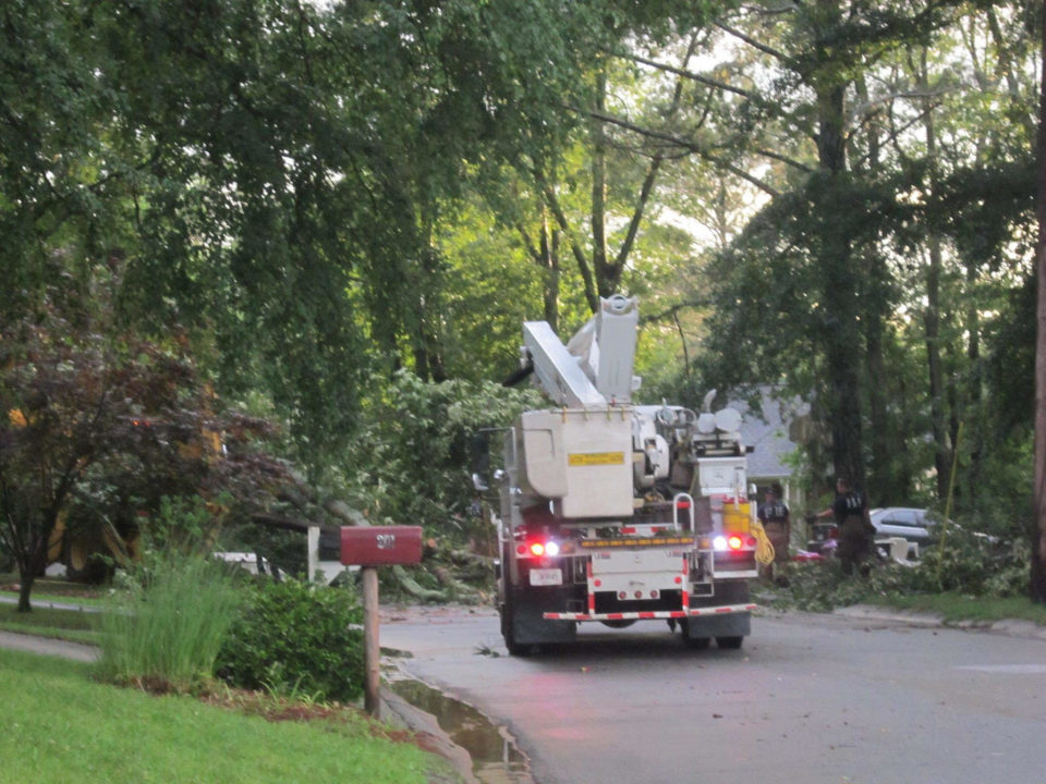
“We have our EMA keeping a close eye on these events,” Carroll County Commission Chairman Marty Smith. “Charles Pope, our Roads Superintendent, who works with our emergency crews will have crews watching the north and south of the county. We have all of our trucks and machinery fueled up and ready to go at a moments notice.”
Carroll County experienced multiple tornadoes in early April of last year. Smith noted that his crews are prepared to respond in the event of more tornadoes in the next 48 hours.
“It’s that time of year when the warmer and cooler air starts to mix together and create these weather events,” said Smith. “We are doing all we can to make sure we are able to quickly and effectively respond to any needs our citizens have.”


